

Written by Christian Maleedy - https://runningchristian.wordpress.com
I have been blessed enough to have run and raced in many hilly and scenic areas of the UK – the Lake District, the Peak District, Cornwall, the Yorkshire Dales, Snowdonia, the Brecon Beacons, the South Downs. However, I’d never done anything significant north of the border.
The Highland Fling follows the first 53 miles of the West Highland Way, from the official start in Milngavie (a small town just a few miles north of central Glasgow) up past Loch Lomond finishing in the mountain village of Tyndrum.
I’ve had my eye on this race for some time, but now finally have the chance to run it. It’s almost 6 o’clock on a cold Saturday morning. We are standing in the car park of Milngavie train station, waiting for the race to start. My flight up from London the previous night had been delayed and pre-race excitement meant that I hadn’t got very much sleep. Drop bags have been deposited in the relevant vehicles, a pre-race bacon roll and coffee consumed; now’s it just a case of waiting the last few minutes for the race start.
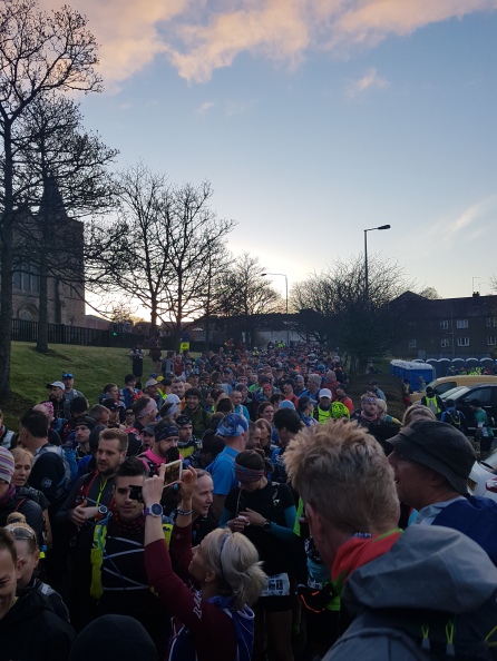
This race began in 2006 with less than 20 runners as a training run for the 96 mile West Highland Way race. Today there are 800 runners nervously awaiting the start (making it certainly one of the largest ultras in the UK). Due to the number of runners, the race begins in three waves. I pick the middle pen and wait for our turn to start.
The mournful sound of bagpipes drifts out from the speakers. “Do you want something louder?” asks the guy controlling the music. Having got a positive response, the crowd is soon swaying to Avicii’s “levels”. As tributes to the late Swedish DJ go, several hundred lycra clad ultra runners bopping up and down in a Glaswegian car park must be fairly unique!
Having watched the first wave of elites and faster runners dash off, it’s now our turn to pass under the bridge, through the pedestrianized centre of Milngavie and turn onto the official trailhead of the West Highland Way. The trailhead is narrow and it’s evidently why the organisers don’t want all 800 runners descending on it at once.
These first few miles trend gently uphill initially through woodland, before later passing holiday cottages and opening out onto a wide track alongside Craigallian Loch.
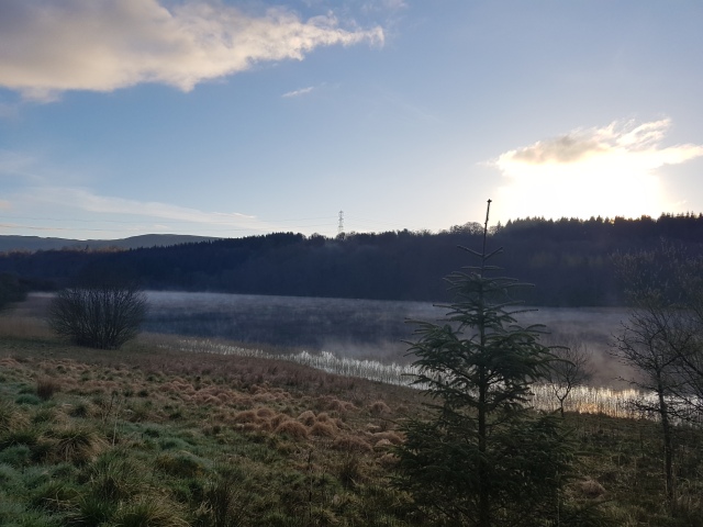
The early morning mist gently rises off the water creating an ethereal atmosphere. Here we are only a few miles north of Glasgow, yet this already feels so remote; the occasional electricity line the only real sign of civilisation.
The first checkpoint of the day is at Drymen after around 12 miles, which I hope to get to in around 2 hours. This first section is a mix of gently undulating trails and country lanes. It reminds me a little of the start of the North Downs Way back home; nothing too technical or challenging so far! It’s not long before the first mountains come into view in the distance, still capped in snow thanks to the long late finishing winter.
On the way into the village of Drymen, we’re sent through a field up a hill to a mid-race kit check. Unlike most of the races I run that have very comprehensive mandatory kit lists, this race only has two mandatory items; an emergency blanket and a mobile phone. Whilst these items could easily fit into a runner’s back pocket, all the runners have opted to carry significantly more items than this in their race vests and backpacks. As well as water and food, I’m carrying various items of clothing; enough to deal with whatever the Scottish climate decides to throw at us today!
Kit check is quickly negotiated and we descend into the first checkpoint of the day. There are five checkpoints along the way, at four of which we can access our own drop bags, which contain the food and drink (aside from water which is provided) that we might want during the race. There are no drop bags at this early check point; just water. As I get my bottles filled, one of the volunteers spots my UTMB t-shirt and we chat a little about that race.
“There isnay bag here, get oooooooout” declares the next volunteer. [Translation: “This is not a drop bag location, therefore please feel free to continue along the trail at your earliest convenience, my good sir”]. He has a point and I’m soon on my way.
This first section has been straight forward but much sterner tests lie ahead. First and foremost of which is the biggest climb of the race; Conic hill which comes in this next segment. The trail begins to trend uphill again as we approach the climb.
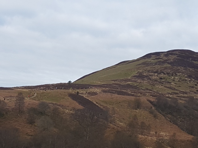
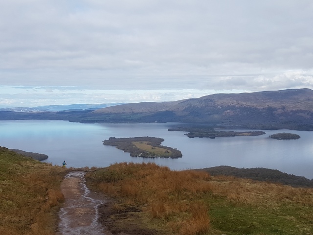
These ascents are difficult to judge; they don’t feel steep up enough to justify walking but an attempt at running them leaves my legs objecting strongly. I settle on a run/walk strategy until Conic hill looms immediately ahead. The climb itself is a slog and reminds me of the many climbs on UTMB last summer. Thankfully the difference here is that this climb only takes a few minutes to reach the top (compared to the 2ish hours that many of the UTMB climbs were taking me). Race photographers are snapping away at the top and the views over Loch Lomond are simply breath taking.
Having been overtaken by a few runners on the way up, I throw caution to the wind and pick up some speed for the descent, gaining a good few places. I can still feel the adrenaline coursing through my body as the descent starts to flatten out leading us directly into the next checkpoint at Balmaha.
This is the first drop bag location and as I enter the checkpoint I can see it operates like a finely tuned machine. A volunteer checks my number and shouts it along to the crew waiting by the drop bags. By the time I have progressed through, my bag is ready and waiting for me. I’ve packed the same items in each of my four bags, a can of coke plus a mix of savoury and sweet snacks. I gratefully drink the coke and although I’m not really hungry, eat a little and stash the rest in my race vest for later.
We are now on the south eastern corner of Loch Lomond, Scotland’s biggest loch. The race will follow the shore of the loch for the next 20+ miles, before heading off deep into the highlands. This next section through Rowardennan Forest is undulating again but relatively runnable. However, I’m unable to take full advantage of this as I hit a low patch. My body if feeling the effects of the South Downs Way 50 followed by a week of running in Snowdonia just two weeks before and my hips and legs object every time I try and get any kind of decent pace going. I know I’m struggling as I’m glancing at my Garmin every few moments, grumbling angrily to myself when I see only another 0.1 of a mile has passed. Again, I’m back to run/walk here and by the time I reach the next Rowardennan, I’m behind my schedule and feeling dispirited.
Retrieving my drop bag, I spend a few minutes sitting and lying on the grass by the loch as I refuel and try to refocus mentally. I’m approximately half-way through the race, with the significantly harder half still to come. I try not to think too much about that and just focus on the moment.
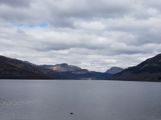
After a fairly disappointing last section, the next few miles are a big improvement and pass by quickly. The trail alternates between hugging the shoreline closely at times and deviating some way inland at others. I’m struck by how much this lochside running reminds me of the South West Coast Path down in Cornwall; no large climbs, but many many short sharp ascents and descents with stunning views over the water.
Above us to the right looms Ben Lomond, the most southerly of Scotland’s famous Monros (Scottish mountains over 3,000 feet). In front of me a runner gets caught by a tree root and goes sprawling, but not before executing a near perfect stuntman roll. I help him to his feet and make a mental note to myself to watch my footing too.
Another forest section brings us to CP4 at Inversnaid. Here volunteers radio ahead runners’ numbers resulting in a massively slick and professional checkpoint process. I open my drop bag and immediately turn my nose up at the savoury items I’ve packed. The only issue with this drop bag format is that it relies on you being able to work out in advance what kind of food you are likely to want at various points in the race. Savoury snacks are normally a good bet for me from past experience but today my body is craving only sweet stuff. I take the chocolate from my drop bag and also visit the table at the checkpoint. Here the leftover contents of the drop bags of faster runners are put out for the others. Half the table consists of various gels. I remark to another runner that these always seem like a great choice at the start of the race but trying to force them down your throat when you’re 30+ miles into a race is another matter entirely. I help myself to a chocolate miniroll which really hits the spot and continue onwards, feeling upbeat again.

As the saying goes “if you’re feeling good during an ultra, just wait a minute”. This next section comes as a massive shock and not an entirely pleasant one. My research of the course was limited to looking at maps and course profiles. Accordingly, I had a good idea of the climbing involved and where the big hills come during the race. What maps and course profiles can’t tell you is about the underfoot conditions. This section is massively more technical than I was expecting. A plethora of rocky scrambles, deadly tree roots, boulder hopping, stream crossings, ascents, descents and mud ensues. Any pre-race ambition I may have held with regard to a finishing time now dies a death on this brutal lochside terrain. Any attempt to get into a rhythm is hopeless as I’m invariably forced to walk. This is single track trail and I’ve now joined the back of a long procession of runners. It’s impossible to overtake anyone and, as it happens, I have no real desire to anyway. I accept that my time goals aren’t going to happen – but that’s ok. I’m nowhere near the cut offs and even a slow walk would get me to the finish within the 15 hours allowed. Having recently committed to adopting a more “mindful” approach to life, I put thoughts of finish line celebrations out of my mind and focus on the moment and the job in hand. Yes, the terrain is tough, but it’s also absolutely stunning and I do my best to take it all in.
Soon, we leave behind the loch for the last time and start heading uphill again. “Two easy miles to Beinglas Farm” declares a volunteer that we pass. I frown to myself, I’d counted on it being more like one mile….hopefully he has got it wrong as I’m now really ready for a cheeky sit down at the check point.
Turns out the volunteer was right about the two miles, but wrong about the easy part! Beinglas is the final full checkpoint with drop bag access. Red and white tape funnels us through the farm and towards the check point. For a moment I’m taken back to UTMB, and the mountainside checkpoints there. I’m really thankful that today is “only” 53 miles and not the 104 miles of UTMB.
Having retrieved my bag, I collapse into a camping chair with a groan of delight resulting in ripples of laughter from the other runners and volunteers. A volunteer confirms what I’d suspected – a slow walk would could comfortably get us into Tyndrum in time. From past experience, sitting for more than few short minutes will result in my legs stiffening up and making getting going again very difficult. I sit as long as I dare before slowly making my way down the farm track.
After a really technical few miles of single track, we are now on runnable double track again. The overall trend, however, is most certainly upwards as we head into more classic highland terrain. I run the flattish sections and walk the steeper ascents.
Soon we hit the notorious “cowpat alley”; a quagmire of mud and the afore mentioned cowpat. Here runners are frequently known to disappear to their knees in the stuff. Fortunately footprints in front of me mark a safe route taken by other runners through the danger.
Uphill slogs are met with lovely runnable downhill sections. Ordinarily I’d be pounding these downhills with joy, but today my body says otherwise. The sound of live music gently drifts from some trees; violins, bagpipes and accordions have been just some of the instruments that have encouraged us along the way during this race. It’s so lovely that people have taken the time to come out. As the afternoon has worn on, we’ve past many curious (if slightly bemused) WHW walkers who have all been encouraging and happy to stand aside as we passed by.
I pass the last minor check point at a road crossing and am immediately met by stunning views of the mountains ahead. I stop for a moment to take a picture and another runner notices my t-shirt declaring “this must be easy compared to UTMB”.
“In theory”, I reply, “though it doesn’t really feel like that at the moment”.
![31400919_2046457365383650_2328742091208785920_n[1]](https://runningchristian.files.wordpress.com/2018/05/31400919_2046457365383650_2328742091208785920_n1.jpg?w=365&h=274)
Jess and I get chatting and run/walk the last 3 miles of the course together. Having not run with anyone else for a more than a few minutes all race, it’s nice to have some company. Incredibly these last 3 miles of the course pass by the quickest as we chat about running in Cornwall, races we’ve done and races on our bucket lists; UTMB, Western States, the Arc of Attrition, the Goat, the Spine. I even manage to gleam a few clues for how to enter the infamous Barkley marathons though I don’t really have any ambitions in that department.
Before long, we’re met by the sound of bagpipes and, as we turn a corner, we see the finish and the famous red carpet ahead. Another runner, who I’ve been leap frogging all day, is keen to entertain the crowd with a 3 person sprint for the finish line. Jess and I both decline as he sprints off and we jog over the line.
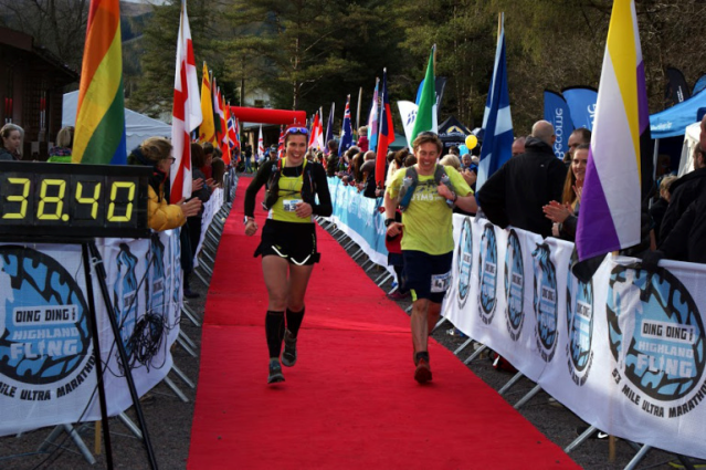
12 hours 35 minutes definitely wasn’t the time I was envisaging at the start of the day, but I’m happy enough given this wasn’t an “A” race and it’s come hot on the heels of a PB at the SDW50. My next race in May is the North Downs Way 50 (which I’m treating largely as a training run) followed by the South Down Way 100 in June (which is an A race and I’m hoping for a good time on).
![31395671_2046457192050334_631325356032262144_n[1]](https://runningchristian.files.wordpress.com/2018/05/31395671_2046457192050334_631325356032262144_n1.jpg?w=381&h=508)
As I sit by the road in Tyndrum waiting for the bus back to Glasgow, I look up at the snow capped mountains. The West Highland way has captured my imagination and I can’t help thinking about returning. Past Tyndrum, the WHW goes through Glen Coe before finishing at the foot of Ben Nevis in Fort William. I can definitely see either the “Devil o’ the Highlands” (a race starting here at Tyndrum and finishing at Fort William, ie the second half of the trail) or the West Highland Way race (the whole 96 miles) at some point in my future. But for now, the Fling has fully lived up to all expectations and left me enchanted.