

Written by James Campbell - https://jamescampbell78.wordpress.com
The idea behind the Cleveland Hills Challenge formed in my mind in around October last year when I stumbled across the Wikipedia page for the Cleveland Hills.
On the page, it lists all the summits in the range with height and grid locations as below:
|
Name |
Grid reference |
Height |
|
|
Urra Moor (Round Hill) |
454 m |
1,490 ft |
|
|
432 m |
1,417 ft |
||
|
408 m |
1,339 ft |
||
|
Cold Moor |
402 m |
1,319 ft |
|
|
398 m |
1,306 ft |
||
|
Tidy Brown Hill |
396 m |
1,299 ft |
|
|
Bilsdale West Moor |
395 m |
1,296 ft |
|
|
Warren Moor |
335 m |
1,099 ft |
|
|
328 m |
1,076 ft |
||
|
324 m |
1,063 ft |
||
|
Park Nab |
324 m |
1,063 ft |
|
|
320 m |
1,050 ft |
||
|
Live Moor |
315 m |
1,033 ft |
|
|
Highcliff Nab |
310 m |
1,017 ft |
|
|
Codhill Heights |
296 m |
971 ft |
|
|
242 m |
794 ft |
||
It got me thinking that all of the 300m (1,000ft) + summits were all in a single range and it was probably possible to summit them all within a single run and quite possibly do that run in a number of different ways.
Having eliminated Codhill Heights and Eston Nab from the list, this left a list of 14 hills and me being slightly OCD (and feeling a little guilty for removing Codhill for a mere 4 metres) I decided that Newton Moor which stands more than 300m and is halfway between Highcliff Nab and Roseberry Topping might make a good addition, especially as it’s on the next ridge along from Codhill Heights.
Having formulated the idea in my head, I sounded out a couple of running friends who agreed it sounded like a fun challenge to have a go at so I went public, created a Facebook group and put it out there in November for people to have a crack at.
There was some chatter over the winter about possible routes and a lot of interest in giving it a go but by the end of January nobody had planned in a firm date. With races now appearing in peoples calendars I decided to give it a shot in April.
I made enquiries about getting a crew together and had positive responses from a number of friends including Peter Kirkham and Shel Winspear whom I’d been Facebook friends with for a long time but had never actually met before.
Having been cajoled into setting an actual date by Jayson Cavill, I set a firm date of April 9th and went public with that. No going back from it once it’s out there.
The run up to April seemed to come really quickly, having performed well in the Hardmoors Three Sisters night race, in brutal weather and completing a 32 mile recce run of the Hardmoors 110 from Staithes to Clay Bank with Brenda Wilkin, Dave Cook and Dee Bouderba in snowy conditions in January I felt confident of my ability to cover the distance and climbing involved as long as I kept progressing my training.
I had also entered a duathlon race, so in between trail running training, I was also doing some cycling (nowhere near enough for the race I’d entered) and road running. I was however during most of February and March piling on weight and I felt it’s effect during Sun City duathlon where I really struggled due to my lack of cycling specific work and the additional weight I was carrying.
Having started to eat more sensibly, in conjunction with my training, I’d started to lose weight in the couple of weeks leading up to 9th April and with it, my running seemed to be improving.
On the Tuesday before the challenge, I met up with Pete and Shel and walked them through my intended route and meeting points so that they’d know where and when to meet me. Having never done any crewing before, I was determined to make things as easy as possible for them and keep meet points to obvious road crossings and all of my kit to one bag.
The route I chose started in Commondale and headed north across Gisborough Moor which I’d recce’d twice in training. Once across into Guisborough Woods I’d head up to Highcliff Nab, then follow the Cleveland Way to the foot of Newton Moor, which I’d follow a tractor trail to the top of and make my way to the highest point (based on the OS maps I’d used to plan the route).
After that, I’d follow the tractor trail down to another part of the Cleveland Way (which loops round to the other side of the moor) and head north along it before making and out and back to climb Roseberry Topping. From Roseberry I’d follow the Cleveland Way along to Easby Moor and round Captain Cooks Monument before descending into Kildale at the first agreed meeting point.
I’d chosen Kildale because it’s 5 minutes’ drive along a the same road from Commondale and has a tea room that would allow Pete and Shel to keep warm, dry and fed while they waited. Based on distance, I’d estimated two and a half to two and three quarter hours for this leg.

After Kildale my intention was to head up the Cleveland Way towards Bloworth Crossing and the next meet up point of Clay Bank, taking minor detours to pick up Park Nab, Tidy Brown Hill Warren Moor and Urra Moor (Round Hill) on the way. For this leg I budgeted three hours as I had no idea what conditions on the most exposed part of the route would be.
At Clay Bank I’d resupply with food and fluids as well as deciding whether to use my poles over the Three Sisters of Hasty Bank, Cold Moor and Cringle Moor before dropping down to the Lord Stones Country Park for another meet up, which again would be convenient for Pete and Shel as there is parking and the café for food etc. I’d allowed an estimate of an hour and a half to get there.
For the final leg, after a couple of recce’s I’d decided to use the Cleveland Way to pick up Carlton Bank and Live Moor then run across the heather down to a lower track which I could use to link up with a path that would take me directly to Bilsdale West Moor where I knew the huge TV transmitter there was slightly south of the summit, but where I’d never actually been before. Allowing for distance and tired legs, I reckoned on about two hours to the finish, following which I’d drop back down into Chop Gate for a pick up maybe a couple of miles on top of the 32 miles I’d have already run.

Having gone through this and what I’d do in various situations such as feeling unwell, getting injured or changing route we were all ready to go.
The night before, I packed all my food/fluids and kit for all weather eventualities into a bag.
The morning of the 9th arrived with damp, and drizzly conditions in Hartlepool. Pete picked me up at 7am as agreed and as we drove to Commondale to meet up with Shel (with children and dog in tow) it became clear that it was going to be foggy on the tops in line with the morning’s forecast. The afternoon forecast was for it to get brighter but with showers expected.
Once out of the car, I decided on wearing a base layer, leggings, thin jacket, hat buff and gloves in addition to the tri-suit I always run these distances in. I was also wearing gaiters for only the second time on a run and was interested to see how well they’d keep dirt out of my shoes over really long distances. For food I had a bag of Wine Gums, a bag of dry roasted peanuts, a bag of salted peanuts, an energy Gel, two Snickers bars and a banana. I also had 500ml water and 1,000ml Lucozade Sport split between two UD bottles and a UD soft flask which went in my back pocket with the food. I had a moment of panic getting out of the car when I couldn’t find my MP3 player and thought I was going to have to complete a long solo run without music, then I found that it’d rolled out of my vest pocket to the back of the car boot.
I got Pete to drive me to the edge of the first footpath then I was off, jogging slowly at first as I unravelled the tangled mess of my earphones (why do they always end up like that no matter how carefully you pack them?)
As I approached the gate that leads onto the moors path, I blundered into a series of puddles soaking my feet with icy cold water. The path beyond the gate itself was submerged and my first dilemma was whether to continue along the path to where I knew there was a bridge or hop over the stream that runs across the route and re-join the path where it loops back and up the hill.
The jog up the hill on fresh legs seemed relatively easy and I settled into a decent rhythm quickly and it wasn’t long before I was off the single track and onto the main path across the moor with was a nice wide trail.
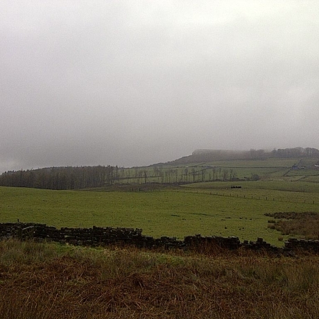
As the trail wound upwards, the mist grew thicker and at times I was down to less than 50m visibility, feeling quite cold I had to use a buff to cover my ears and neck.
Soon I was within sight of the cairn that precedes the summit and decided to run to the cairn to see if it was an appropriate summit marker or if the junction with a path ahead was truly the highest point of the moor. A couple of minutes of boggy heather trudging later told me that the path junction was the true summit.
With the first summit conquered in 33m:39s I had some food and got a jog on, using the gentle descent to pick up some of the time I’d lost walking the steeper inclines on the way up. The fog seemed to lift a little as I descended but was quickly replaced by drizzly rain. I passed the trig point on the moor and turned the corner onto the path that runs parallel to the top of Guisborough Woods. I ran to the beat of the music along the path until I reached the gate into the woods themselves and turned onto the fire road that leads up to Highcliff Nab. I took a walk break and used the time constructively to text my wife, Natalie and let her know that I’d fed the dog before I’d left the house just in case she gave her a bonus meal. The fog seemed to hang in the woods and visibility was quite limited, so I was surprised when I arrived at the top of the hill where the woods cleared and the path headed along the ridge to Highcliff Nab. I reached the summit in 57m:43s and rewarded myself with a banana, munching on it cheerily as I descended via the rocky path onto the Cleveland Way.
I passed a couple of early morning walkers and continued along the flagstones towards Black Nab and my next objective, Newton Moor. About halfway along the path, the fog seemed to suddenly clear and I stopped to look back at Highcliff Nab and take a picture before heading on quickly.
As I ran I realised that the soft flask in my back pocket was bouncing around and it was annoying me, while I’d almost emptied the one in my vest so I stopped at the path junction before the ascent to Newton Moor and emptied the soft flask into the bottle which made me feel happier.
To ensure I hit the correct part of the summit, I set my Suunto into navigation mode where I had all of the summits saved as Points of Interest and my planned route for the day saved. My route took me up the winding tractor trail as expected, but I spied a single track leading off the side to the ridge I needed to be on. As the tractor trail was rocky and muddy in equal measure, I saw this as a good option and quickly got onto the ridge which I found was covered in nice, deep, wet heather but as expected had a single path running across it from north to south. I followed the directions of my route south and passed a cairn, checking to see whether this was my waypoint, nope, onwards through more leg soaking heather pleased to note that the gaiters kept the various loose bits of heather and other grit from entering my shoes. Ahead I could see a small standing stone and it soon became obvious that this was the actual summit as marked by my waypoint. I touched the stone at 1h:23m and retraced my steps with Roseberry Topping firmly in my sights.
Once back on the tractor trail I bounced down the less boggy bits of the hill and danced around the puddles where I could but my feet got a good soaking two or three times on the way down to the Cleveland Way where I turned right and headed along to Roseberry. Once through the gate onto Little Roseberry I thought I could see somebody on top of Roseberry Topping but when I looked again a minute later they were gone. The stones on the path down to the foot of Roseberry were slippy and I was descending with care, conscious that I had a long way to go and didn’t want to pick up a knock nor did I want to fall and break something here which was quite far from vehicle access.
Soon I was climbing Roseberry Topping, using the same technique I did on Hardmoors 55, very small steps with minimum pressure placed on the muscles, no real rush. I was feeling strong and running to plan. I was soon on the top and run up to touch the trig point at 1h:44m before heading straight back down the way I came. On the way back up to Little Roseberry I passed a walker who commented that the weather was awful. I looked ahead to Captain Cooks and noted that for the first time today, the fog had cleared enough for me to see the monument, however I looked back at Roseberry to find it obscured by fog just a couple of minutes after being able to make out the summit clearly.
I ran most of the path to Gribdale Gate, passing more walkers who were also doing the same little dance as I was around the boggy bits and puddles. I arrived at the foot of the climb to Easby Moor from Gribdale Gate at 2h:08m and began to walk up at a decent pace. I could see a dog walker and a family ahead making their way up and I resolved to overtake both before the summit in order to give my walking a bit of focus.
About halfway up I managed to overtake the dog walker and about three quarters of the way up I overtook the family of walkers. As I approached the top, I started jogging again and touched my next waypoint, Captain Cooks Monument at 2h:22m and began my descent into the always boggy woods aiming to hit Kildale by the 2h:45m point.
Once through the woods and onto the road I managed to maintain a consistent pace all the way down into the village, the only obstacles being a few sheep who’d chosen (or rather their lambs had forced the decision) to feed their lambs in the middle of the road.
I arrived at the cars bang on 2h:45m, had a quick catch up with Pete and Shel, dropped off the now empty soft flask into the boot of the car and resupplied my back pockets with Snickers bars for the journey ahead.
Having given an estimate of three hours to get to Clay Bank I headed up Battersby Bank to my next objective, Park Nab, another summit I’d never visited before. On the way up, I took some photos of the improving visibility across to the Three Sisters and continued at a steady fast walk up the hill. I eventually reached my turning point off the main road and headed up a muddy tractor trail towards the Park Nab summit. At this point I was making mental notes to update the Challenge Facebook page with landmarks for each summit. Park Nab was entirely devoid of any useful marker. In fact I hit the summit at 3h:12m but continued further than I needed looking for a decent marker until it became obvious I was descending again. I turned around and made my way back over the muddy, greasy summit sliding around a bit as I went and earning my feet another soaking.
Once back on the road I cracked on to my next objective, Warren Moor which was less than 1km away. I arrived at the gate/cattle grid in the road where my Suunto was telling me to divert left onto the moor to reach the summit, but it was obvious from my current position, that I was already at the highest point of the moor, so marked time at 3h:22m pleased to have picked off 7 summits in a fairly quick time.
I was now heading onto the most exposed part of my route, the old coal road that leads on to Bloworth Crossing, most of which sits over 400m above sea level and often throws hostile weather at you. The last time I crossed this section of the moors was in January, after midnight in drifting snow and thick fog. At least the fog was clearing up today and I actually thought I could feel the temperature rising a little. I was running well on the slight incline, only breaking to walk when the path steepened every now and again. I could see the ridge upon which my next target, Tidy Brown Hill sits from a long way off and I kept moving steadily, only stopping once to take a couple of photos of the trail behind me and another of Captain Cooks/Roseberry in the distance.

I was soon level with the ridge I needed to be on and switched Suunto back into nav mode as I looked for an easy path up through the thick heather. I soon found a section that had been cut back and started to climb towards the waypoint marked in my watch. I’d only climbed about 10m or so when the ground got very squelchy and I was having to hop over bouncy peat to avoid the masses of standing water. As I reached the top of the ridge I could see that thew waypoint was again going to be lower than the highest point. I was too busy looking for a marker when I went knee deep into a muddy puddle. At that point I turned back and headed to the ridge where I took my mark of a lone mini pine tree planted roughly at the highest point. I was now 8 summits up in 3h:51 minutes and just under 26km into the run, which I guessed was around half the distance I needed to cover. If that was true, I was well ahead of the 8 and a half hours I’d guessed I’d take.

I bounded back down to the Cleveland Way, again thankful for the gaiters in keeping the nasty stuff out of my shoes and cracked on towards Bloworth. At this point my legs were starting to feel a little sore, so since I was alone I decided to repeat the mantra that had worked so well for me on this stretch during last year’s Hardmoors 55. I was soon running along repeating “I am strong, I am fit, I am running well, I am running pain free.”
Pretty soon, the pain had subsided but the sun had come out, another thing I noticed was that there wasn’t a breath of wind, almost unknown for this trail. I made sure I was drinking regularly and plugged on to Bloworth, reaching the turn towards my next summit Round Hill, which sits atop Urra Moor at 4h:23m. As I passed Bloworth, I was in bright sunshine and was about to start stripping layers off, when a welcome rain shower made an appearance keeping me cool and refreshed.
The path was getting quite busy too, I passed several walkers which helped me pass the time greeting them. The trig point for Round Hill came into view and I turned off the path and headed up to the summit on 4h:45m. This was the highest point of my route and since it was also the highest point of both the Cleveland Way and the North Yorkshire Moors, I paused to take some photos, one of which was the Bilsdale Transmitter way off in the distance. I made my first of many promises to the Bilsdale West Moor then. “I’m coming to get you!”

I was off on my toes again, this time headed downhill and making faster progress, knowing that I soon had some of the toughest climbing to do, I took some paracetamol while on the move to make sure that any aches and niggles were dulled before I got there. I was now sweating profusely and had taken my hat, buff and gloves off and stuffed them in my back pocket.
I was now bounding downhill heading towards my next meet up with my crew at Clay Bank, as I got onto the road I could see Shel and the kids waiting there and I jogged down the road, emptying the last of my Lucozade into my mouth as I went.
At Clay Bank, I stripped off my base layer, knowing that I was definitely too hot with it on, but decided against stripping my leggings off. I soaked the buff on my wrist in cold water, topped my water and Lucozade bottles up and stuffed some more Snickers into my back pocket. Before heading off, I decided to play my trump card and downed a can of Red Bull in one go.
I grabbed a banana to eat while climbing Hasty Bank and then I was off, across the road and up through the woods back towards the Cleveland Way gate. I finished my banana half way up the steep section of Hasty Bank and feeling hot, sloshed some fresh water over my head and upper body.
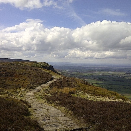
From the gate to the top of Hasty Bank took around 12 minutes getting me to my next summit on 5h:37m. With the sun shining and the skies clear, the views were stunning so I stopped again to take some photos before I was off and heading down through the Wainstones towards the foot of Cold Moor. I was feeling really strong as I climbed Cold Moor (this probably had more to do with the Red Bull than anything else) and I kept cool with regular slurps of drink and sloshes of cold water over my head. I crested Cold Moor and ran across the summit on 5h:58m.
As I reached the top of the descent, I could see a pair of walkers almost at the bottom, I targeted beating them to the top of the next climb. I bounced down the side of the hill and overtook them going through the gate at the bottom of the hill, exchanging a greeting as I passed then jogged on to the foot of the next climb, which is one of the toughest on the Cleveland Way. I fast walked the hill, but could hear the voices of the walkers behind me, having closed the small gap I’d managed to make running across the valley floor during the first part of their climb. I pushed a little harder, at one point too hard, slipping on a rock but I made good progress up the hill, as I got onto the flat section at the top, I’d built a decent gap and I jogged on to the turn I needed to take to head up to the cairn that marks the summit of Cringle Moor around 100m from the main path. The route up to the cairn was singletrack, muddy, wet and slippy. Needless to say, my feet got wet again.
I touched the cairn on 6h:23m and jogged back down to the main path, passing numerous walkers on the way, including the ones I’d previously passed. I was down descending quickly but carefully down towards the Lordstones Country Park and my next rendezvous with Pete and Shel. On the way down I could feel a hot spot forming on my left little toe, I ignored this and pushed on, in my mind I was smiling, only 3 more hills to go, I’d well and truly broken the back of this run and I was still feeling pretty good.

At Lordstones I topped my bottles back up, thought for a minute about taking my poles for the final leg then changed my mind as I was feeling good. I jogged out of Lordstones at 6h:42m, having spent about 5 minutes sorting myself out for the final stretch. The sun was still very warm on my neck and I was again sloshing water over my head as I climbed. Carlton Bank is another set of steep steps and I was expecting my calves and thighs to be sore at this point, but they weren’t and I felt that I was climbing comfortably within myself. I reached the trig at the top on 6h:54m and took some more pics before moving on. As I jogged down the rubble strewn path away from Carlton Bank, I caught my left little toe on a rock and confirmed for certain that I had a pretty decent blister forming, the right little toe also started sounding off too but I ignored both and pushed on singing alone to the music on my MP3 player, which I was pleasantly surprised that it was still pumping out tunes. I reached the penultimate summit of Live Moor on 7h:16m just as the music reached the last track and returned to the beginning of today’s playlist.


I’d recce’d some of the paths around this part of the moor as part of my Lyke Wake Challenge prep and decided to use that to my advantage now, taking a shortcut across the heather to a track down by Snotterdale Plantation rather than heading up to the glider station at Carlton to pick up the trail to Bilsdale.
I made slow progress back up to the main trail but I’d saved myself some distance at least. I was now facing south, heading directly towards the transmitter, promising Bilsdale that I was coming.

The trail was rocky and soon, both feet were feeling sore, hotspots on the little toes and the ball of my right foot were slowing me, but I kept pushing on. Just past Barkers Crags, I passed some runners coming the other way, one wearing a Hardmoors 26.2 finishers shirt and I greeted them fairly manically as I pushed upwards towards the top of the moor.
I was now almost at Cock Howe and the transmitter seemed to be just as far away as it was half an hour ago. As I passed Cock Howe, at 8h:18m, the battery on my MP3 player finally gave out and I was left with only the crunch, crunch sounds of my footsteps and the occasional honk or screech of moorland birds for company
In the distance, I could see a cairn by the trail and I focused on getting there despite my tiring legs and sore feet. I arrived at the cairn which was at the top of a bit of a plateau on 8h:36m. I checked Suunto and could see that my final waypoint was around 200m off into the heather at my two o’clock. There was no real difference in elevation between the cairn and the waypoint off in the heather so I stopped the clock on 8h:36m:59s. Challenge complete and a happy, but tired man.

I walked was to Cock Howe then jogged down to Chop Gate to meet Pete and Shel at the Buck Inn. They’d been fantastic support all day and Pete presented me with the perfect tonic as I arrived, a pint of coke which I necked in one.

The Challenge lived up to all I expected it to be, epic in it’s 52.6km distance and 1,716m elevation gain. The weather was very kind all things considered. Kitwise I was happy with my choices and foodwise, I was happier with how things had gone that any long run I’ve ever done.
Eating every 15 minutes, alternating Wine Gums, dry roasted nuts, salted nuts then a banana or Snickers on the hour (with the exception of a single gel at the 2 hour mark) worked very well and my stomach was the most settled it’s been on a run over 20 miles. I’m now of the view that gels may be the thing that’s caused previous queasiness.
For fluids, I felt that the Lucozade Sport worked well, supplemented now and again with an S Cap. I’m interested to see how I’d go with a more complete carb/electrolyte drink like Mountain Fuel. That’s something I’ll probably try before July when I take on the Lyke Wake.
The route, I think I picked a good option, the only downside being that the Bilsdale section at the end was a bit of a dirge, particularly when I was feeling tired. I’d be interested to see what it’d be like starting at Scugdale, doing Live Moor, Bilsdale then Carlton and working round the rest of the route in reverse. Starting at Slapewath and doing an out and back to Gisborough Moor might be slightly quicker too. Lots of options to explore for future attempts.
I can’t sign off without giving the huge thanks due to my crew, Pete Kirkham and Shel Winspear. Both of whom gave up their time freely, spent a day driving from place to place and making sure I had everything I needed. The completion of this challenge is as much yours as it is mine. Thank you!