

Written by Paul Baldwin - http://pbracereports.blogspot.co.uk
When I arrived in Keswick on Friday afternoon I was in confident mood, confident that I could take the worst that the Lake District could throw at me, and confident that I could hold my own in this race. When I finally got to bed at 3am on Sunday morning after just over 21 hours on the mountains, I had been humbled by the experience, humbled by the power and physicality of these peaks, and humbled by the calibre of the other athletes in the field.
The Lakes 10 Peaks is an appealingly simple concept – the 10 highest peaks in the Lake District within 24 hours. The website description cites 73km and 5,600m of vertical ascent, but given that you are free to choose your own route as long as you visit all the peaks and checkpoints in the right order, the actual distance you cover can vary significantly. My GPS track showed 77km and 5,450m of ascent. The race was created 6 years ago by Paul Smith (our race director), partly to raise money for Macmillan, but also just to see if there was anyone else out there who fancied trying to run the biggest 10 peaks in the Lakes in a single day. This year’s group of 82 starters took the total number of people that had taken up Paul’s challenge to over 1,000 – a superb achievement by him, his assistant race director Mark Bottomley, and most importantly all of the amazing volunteers who man the checkpoints in some extreme places in vile conditions… Thank you all!
So anyway, here’s how it went: I set a 3am alarm for Saturday morning to give plenty of time for breakfast, and to get to the 4.15am meeting point in Keswick for the coach ride to the start at Swirls Car Park. The midges there also enjoyed a hearty breakfast at our expense, but thankfully Paul kept the pre-race briefing brief, so we were off on time at 5am, with a 50 minute climb to the top of Helvellyn, our first peak of the day. I was competing as a “pair” with Rich Knowles whom I met running the 10 Peaks in Brecon last year, and as we rock-hopped our way down from the summit, with the early morning sun illuminating Thirlmere below us and the high peaks to the west, we both looked forward to the day ahead with great confidence.
 |
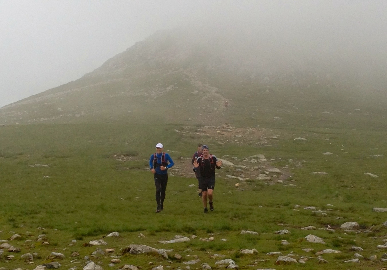
| Rich and Paul in confident mood (copyright SportSunday) |
We stopped only briefly at the first checkpoint at the southern-most end of Thirlmere – just enough time to refill water bottles and grab a Clif Bar to munch on the move – and set on up the Wythburn valley. The map shows several areas of “bog” in this valley, and in this respect our beloved Ordinance Survey has shown true British understatement. As my legs repeatedly disappeared to above the knee into peaty water, I began to appreciate the race director’s sadistic sense of humour, and realised that this was going to be significantly tougher than I had expected. It was with great relief that we reached higher and drier ground at High Raise (our next peak, a mandatory one, but not one of the “10”), but by then the damage had been done – I would have to put up with soaking feet for the next 10 hours and the resulting trench-foot blisters would haunt me over the second half of the race.
 |
|
View from High Raise, heading off in the wrong direction!
|
From High Raise we followed another group of four runners heading off a good pace along a well-marked path. About 15 minutes later I realised we were going the wrong way. Checking my GPS we worked out a route to regain the right path going cross-country across some rough fell, but we had added an extra kilometre to our journey and lost a fair amount of time. It was however a fortunate early lesson not to blindly follow anyone, but instead to keep a constant eye on the GPS. In preparation for the race I had spent many hours at home making sure our route was correctly and accurately programmed into my watch, so it was pretty dumb not to use it. Some might consider the use of GPS in a navigation event such as this as tantamount to cheating, but the rules allow it, and there were to be many occasions later in the day, when conditions had massively deteriorated, when I would offer up thanks to the designers of the Global Positioning System. Simply put, without my watch, we would not have finished.
The next two peaks came quickly – Bowfell and Esk Pike (the latter again being compulsory but not one of the “10”) – but by now the weather had changed with foggy clouds being driven through peaks by very strong winds. We jogged into the second checkpoint on the col at Esk Hause after 4 hours 45 minutes to be welcomed by Sarah (my wife) and Blue (our dog) who had hiked up from Seathwaite to meet us. Blue’s welcome was as cool as the biting wind – I think he was understandably keen to get down and back into the warm – but seeing Sarah was a tremendous boost and she did a terrific job in filling us up with water and chivying us on our way.
 |
| Conditions deteriorating at Esk Hause |
It only took just over an hour for us to bag our next four peaks – Great End, Ill Crag, Broad Crag and Scafell Pike – as they are all relatively close and only have minor climbs between them. The biggest difficulty at this point was actually finding the peaks as visibility was down to less than 10 metres and locating the right cairn was not always easy. The GPS guided us in most cases, but for some reason I had not programmed Ill Crag with sufficient accuracy and after 5 minutes of aimless wandering around looking for it, a Spanish fellow competitor spotted it for us.
 |
| Paul and Rich on summit of Scafell Pike |
Standing at the top of the highest point in England, Scafell Pike, Rich and I asked another competitor (Chris Tuton) to take our photo. After a short discussion with him on the correct way off the peak and how to approach Sca Fell – the next peak and one of the most dangerous – Chris decided to join us and cooperate on navigation. We were now three.
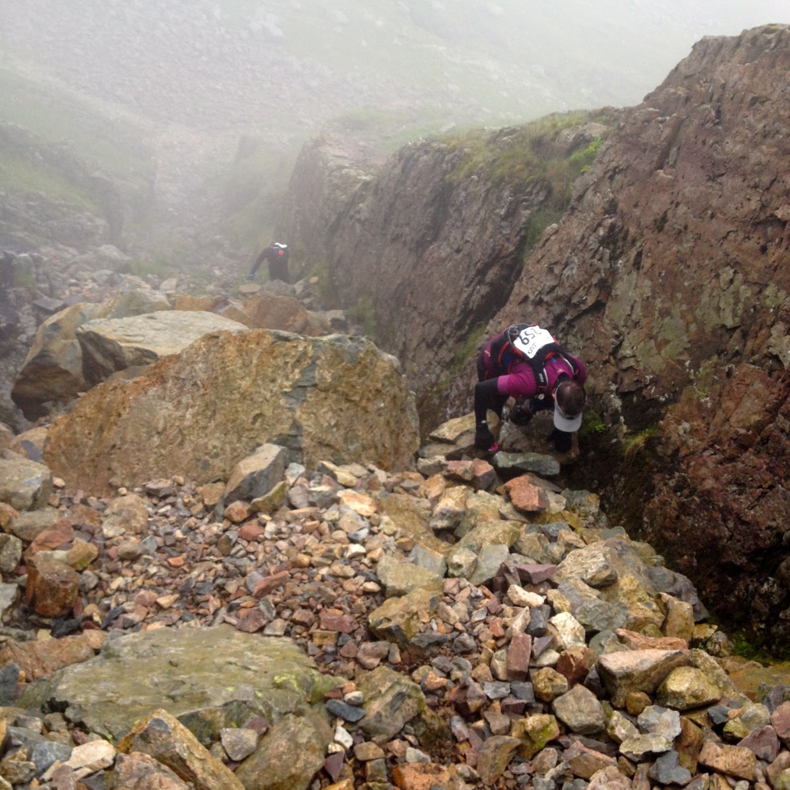 |
| Chris climbing Foxes Tarn waterfall |
Planning for the event, it was the ascent of Sca Fell that had most worried me. I knew that we would not make the 10am deadline to be able to use Lord’s Rake, and indeed I was not sure that I would have wanted to use that precipitous route in such poor visibility. Given that Broadstand was declared out-of-bounds by the race director as being too dangerous, we were committed to the climb up the Foxes Tarn waterfall, a longer route which involves a descent from the “coffin box” at Mickledore, and thus also a longer climb up. In theory it is the “safer” route to the summit, but whilst our good friends at the Ordinance Survey might humorously mark it as a “footpath”, in fact it is an all-fours scramble up a 45-degree boulder-filled waterfall. Rich struggled manfully to conquer his vertigo.
 |
| Rich overcoming his vertigo |
At Sca Fell peak we bumped into an elderly local “man-of-the-mountains” type in his tweed cap, staff and plus fours who asked what we were up to and what route we had taken. We explained the event, our route up to the peak, and the restrictions on Lord’s Rake and Broadstand. His response was “ar’ve dun Broadstand many a’time, nowt wrong wit’ it” – no doubt he did it in his trusty hobnail boots armed with nothing but a slab of Kendal Mint Cake.
At this point there is a major route decision to be made: the standard route would involve descending back down the Foxes Tarn waterfall, climbing back up to Mickledore, then taking the Corridor route to Great Gable before heading west on a very long out-and-back trip to Pillar. We had decided that we preferred the alternative route, heading west off the summit of Sca Fell down to Wasdale, then climbing up Black Sail Pass to bag Pillar, before heading back to Great Gable. Whilst slightly shorter in distance, this route does involve significantly more climbing, but to be honest the deciding factor in choosing the alternative route was that it avoided going back down the dreaded waterfall! In the event, our choice was the most popular with around 70% of competitors going that way.
It was not until the results were published that Rich and I realised that we were actually leading the “pairs” race at the top of Sca Fell, but Mark Clayton and Kevin Minter in their matching fluorescent yellow shirts – a smart move given the fog! – were only 5 minutes behind us. However, if it is the case that there is no easy way up Sca Fell, it is also true that there is no easy way down, and whilst we floundered over steep boulder fields, our rivals used their local knowledge to find a speedier and less tiring route, and pulled out a lead that we were never to recover.
We limped into the checkpoint at Wasdale at 1:15pm after eight and a quarter hours on the go. The tricky descent of Sca Fell had sapped our thighs, and by now my wet feet had started to blister on the soles. We had a team discussion on how we were feeling, and it was clear that our pre-race targets for times and placings were proving to be completely unrealistic. We agreed that from now on our race was only about one thing – finishing within the 24 hour cut off. We knew that we had seriously underestimated this course, and that we still had some really tough hours ahead of us. Rich suggested that we stopped in the pub at Wasdale for a beer – I guessed it was a joke, but had a feeling he might have been serious!
Following the Black Sail Pass path out of Wasdale, our spirits were boosted by having agreed our new goal and by the easy-going conditions. It was not to last. Towards the top of the pass the path steepens considerably, and given the path had petered out, I decided there was little to lose in “cutting the corner” and heading directly uphill north-west to gain the track to Pillar. After 30 minutes of scrambling on all fours up a 45-degree scree slope, with Rich’s vertigo causing him to teach some new swear words to the bemused sheep watching us, we finally got back onto the Pillar track. I am not sure my decision was particularly popular with Rich or Chris, and from then on I decided no more short cuts!
The walk up to Pillar is long and tedious with several false peaks, and by now the wind was really getting up so the exposed summit was not somewhere to linger. The good news was that this was our 8th peak: 80% of the way there! The bad news is that this was only the halfway point in distance, and given that over 10 hours had passed since the start, we now knew that our best-case scenario was finishing in the small hours of the morning. Turning to head back eastwards along same route we had climbed, we were treated to a spectacular view of our next peak – Great Gable – 5km away. Lit by the late afternoon sun, it had the appearance of a champagne cork: circular with a flat domed top and vertical-looking sides, and absolutely no obvious route up it!
It took nearly 90 minutes to get to the Beck Head checkpoint at the base of Great Gable, and by some cruel joke the lovely evening sunshine had now turned into a howling gale pushing rainy clouds over the passes and the peaks. I am not sure what the marshals at Beck Head had done to offend the race organisers, but this was one horrible place to have to spend the day. The amazing dedication and good spirits of these volunteer marshals is humbling (that word again!) and I can only repeat my thanks for their support and encouragement.
Great Gable is not a long climb but it is quite technical with large boulder slopes demanding considerable care in the high winds and poor visibility. In some ways the descent is more difficult – there is no marked route and it’s all too easy to end up on top of a cliff or a steep scree slope. The fog had made us totally reliant on GPS for route finding, and with my watch battery hitting 10% I was thankful that I had brought a second watch to switch over to. I think the small group of short-course competitors that we guided down off the peak was pretty relieved as well.
Just over an hour later, nearly 14 hours after the start, we rolled into the next checkpoint, the YHA at Honister Pass. We were totally exhausted, our thighs were shot, Chris was struggling with some digestive issues and desperately needed a toilet, and my blisters made every sharp rock feel like a red-hot poker being jabbed into my soles. But, we jogged into Honister with elated smiles on our faces because we knew that Sarah would be there to meet us, offering practical assistance and moral support; we knew that there would lashings of hot sweet tea and hot food available; we knew we could access our drop bags, which for me meant the relief of a change into dry shoes and socks; but most importantly I knew that if we could get to Honister then we could get to the finish. For sure, there was still a lot of distance yet to cover, we still had the dreaded Skiddaw to climb, and it would take us another seven and a half hours, so we would have to dig deep. However, the rest of the course was relatively straightforward, and even if we had to crawl up Skiddaw, I now felt that somehow we would get to the finish.
Leaving Honister we decided to detour from the standard route, instead taking the road down towards Borrowdale and then heading north on the Coast-to-Coast path – an alternative that is slightly longer but has much easier conditions under foot, and is downhill all the way to the next checkpoint at Nichol End. As we walked, and occasionally jogged, north alongside Derwent Water we could see Skiddaw ahead of us, looming ominously over Keswick. Whilst the lakeside conditions were mild and warm, we could see that dark clouds were accumulating over the last of our 10 peaks. With their perverse sense of humour, the organisers had kept the longest single climb of the route for last, and we now knew that not only would that last climb be in the dark, it would also be in bad weather.
At Nichol End we caught up with Bernhard Corfe whom we had last seen at Pillar over 8 hours before. He was slumped in a deckchair considering dropping, but after a quick chat agreed to join our group heading for Skiddaw. We were now four. He was a most welcome addition to the team as he was really strong on the 2-hour climb – with his red head torch pointing backwards, he literally gave us a guiding light to follow in the dark and fog. Reaching the last of our 10 peaks at 20 minutes past midnight, I had anticipated some form of minor celebration. However, with a gale force wind belting horizontal rain into our faces and making any form of communication impossible, it felt a dangerously exposed place and we just wanted to get down and somewhere warm as soon as possible. Despite visibility of less than 5 metres, the GPS guided us quickly and surely to safety, and within minutes we were warming up with a slow jog on the path down towards Keswick and the finish.
The statistics:
- We came 49/50th out of 65 finishers, and out of 82 starters (i.e. there were 17 DNFs)
- We were 2nd in the pairs competition out of three finishing pairs
- My GPS recorded a distance of 77km, 5,450m of vertical ascent, and 8,500 calories
- The equivalent flat distance was over 120km
- Our time of 21 hours and 2 minutes was nearly twice that of the winner (Ross Litherland) who came home in an awe inspiring 10hr 46mins
- The average time for the 65 finishers was just under 18 hours – the calibre of our fellow competitors is truly humbling
Lessons:
1. This is not a “running” race. It is just too steep, rocky and technical for anyone other than the real pros to spend much time running. I ran for less than 10% of the distance. Given this, my training programme of running five and a half minute kilometres around the largely flat local parks was not particularly useful – better preparation would have been clambering over wet boulders in a wind tunnel, whilst blindfolded.
2. When they say this is a navigation race they are not joking. When the weather is bad, navigational competence makes the difference between a finish and a DNF. Good route choice can save not just seconds but half an hour; bad route choice means a leg sapping scramble over boulders or though a bog. Planning and preparation is essential, as is knowing the route and terrain well enough that you can find your way in the fog. Never just assume the group you're following knows where they're going!
3. Protect your feet! Wet feet can be tolerated for a few hours, but five to ten hours of wet feet means trench foot and blisters. If the sadistic race organisers must put a massive bog near the start, either find a way to keep your feet dry, or carry spare socks in your backpack.

Final Thanks:
I have already expressed my thanks to the race organisers and the amazing race marshals. However I will finish with thanks to Sarah: for putting up with my absence for endless hours of training runs; for crewing for our ever-expanding team, being there for us with encouraging words and practical help at the checkpoints; and most importantly, for saying “yes” when I asked whether I could do this event on our wedding anniversary!